1. Map of water reservoirs at Byzantine Umm el-Jimal
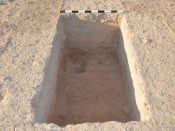
FF.1. The undisturbed red soil at the bottom, dug through to bedrock in the upper left, was covered by an accumulation of soils with artifacts ranging from ashy near the bottom to grey from about 60 cm below the surface. 17 June 2015.
Satellite image showing Byzantine-Umayyad Umm el-Jimal between neighborhoods of the modern community, with modern farms completing the surrounding spaces. The green vegetation band on the upper right represents the course of the seasonal water flow in the eroded depression that held the ancient supply canal.
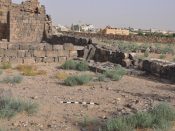
FF.2. The row of stones proved to be the bottom course of a field wall. 1 June 2015.
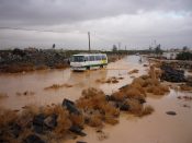
Water filled Reservoir R.1, winter storm, Feb. 1 2012. Umm el-Jimal house and olive orchards in the background.
Garden west and south of House 77. FF.1 was located in the left center of the garden.
Same reservoir, R.1, as above on 2 Sept. 2014; preservation needs: cleanout and water-proofing.
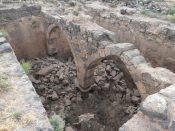
FF.3, at the meter scale stick, was located outside the Praetorium Reservoir, 9 June 2015.
