UMM EL-JIMAL WATER SYSTEM PRESERVATION AND REACTIVATION
UMM EL-JIMAL PROJECT (UJP)
Report on Field Work, 11 Oct – 13 Nov, 2015, to the Department of Antiquities
Funded by NORHED/NORAD of the Norwegian Government as part of a collaborative grant on the theme “Urban Transformation” in cooperation with the University of Bergen, Norway, and Birzeit University, Palestine.
Bert de Vries, Umm el-Jimal Project Director, 6 December, 2015
Introduction: Rehabilitating the Great Roman Reservoir
- Concept plans described in the May-June Field Work Report, the Umm el-Jimal Water Project combines preservation of the ancient system with its reactivation to supplement the water supply available from Jordan’s conventional public water supply infrastructure for modern Umm el-Jimal. Because the great Roman Reservoir was preserved for use as a modern water source sixty years ago, it was decided to clean and rehabilitate that as the first and relatively easy step in the “reactivation” portion of this project. To enable this the Umm el-Jimal Municipality helped pump the small amount of water remaining from the previous winter (see Figure 11) so that the thick layer of sediment could dry out before its removal. The immediate goal was to remove this sediment, and numerous stones, before the onslaught of the rains of the 2015-2016 winter. This, and the reopening of the supply channel were completed by 13 November, just days before rainfalls began the replenishment of the reservoir.
- MethodThe sediment in the reservoir accumulated since a prior cleanout about 15 years ago. Because the bedrock bottom is undulating and varies in depth, the accumulated sediment varied from 0.10 to 0.60 m, for an average estimated depth of 0.35 m, which comes to about 400 cu m of soil. In addition to that, there was a large accumulation of basalt blocks which had been thrown in in acts of vandalism motivated by boredom.To preserve the cement sealing layer applied as waterproofing in 1954-1955, it was not possible to use heavy equipment, so that a plan was set up by Foreman Ali Aqil and Field Director Muaffaq Hazza to remove the soil and stones by hand. The basic equipment used included a number of 5-gallon paint and plaster buckets for the soil, and a sling for the large stones. A crew of 20 workers, residents of Umm el-Jimal, many of whom had been employed on the UJP previously, were divided into teams for this work. In case of the stones, which were removed first, smaller ones were carried out by hand up the birkeh stairway and larger ones were slid up a track made of two large metal pipes, pulled by a group of five using a rope and sling (see Figures 23-27 below). The soil was moved by having a group of men below fill the buckets, and a group above hauling them up with ropes.The Municipality of Umm el-Jimal – under the leadership of Mayor Hasan Fahed al-Rgaibeh – matched this UJP input by providing a front loader and trucks to haul the sediment soil away and distribute it on the shoulders of the main streets of the village with the goal of creating decorative garden beds.
- The Great Roman Reservoir: Prior Research and Use History

Figure 1. Map of reservoirs of Byzantine to Modern Umm el-Jimal. R13 is the Great Roman Reservoir. 
Figure 2. Butler 1913 Ill. 138. The Great Reservoir; View from the Southeast. Archaeological Archives, accessed November 25, 2015, Identifier # 925; http://vrc.princeton.edu/archives/items/show/10746. 
Figure 3. North side and NW corner of reservoir in 1905 photograph. The “draughted masonry” is exposed where the ancient coat of thick plaster (called opus signinum by Butler) has fallen off. The “coping of flat and well fitted slabs” is visible on top of the wall in the segment on the right. 
Figure 4. 3 November, 2015, 110 years later, and 60 years after re plastering of the masonry and bedrock. The bosses of the draughted masonry remain visible as bumps in the thick layer of cement, but the “coping” has been removed. 3-11-2015. 
Figure 5. Dedication of USAID funded re-plastering of the reservoir: “Inception of the repair of this reservoir was on 22 December 1954; and completion was on 28 February, 1955. The writer of the line of text was Rakan Ibn Awdah es-Serour.” 10-21-2015. 
Figure 6. Water drawing station built in the 1955 preservation. The stones on the right and the left used to protrude to provide standing space for a person drawing water with a bucket on a rope. They were broken off by vandals. 3-11-2015. 
Figure 7. Graffiti over graffiti over the stairs, 19-10-2015 
Figure 8. Wadi Za’atari in Umm el-Jimal, 1-2-2012. 
Figure 9. Supply Channel, NW corner of Umm el-Jimal, 1-2-2012 
Figure 10. Roman Reservoir the day after the rains, 2-2-2012. - What Butler Saw.Butler’s description of the reservoir, referencing this photograph, follows:
“The great reservoir, 40 m. by 30 m. square, is situated a little east of the center of the town. It was partly excavated in in the solid rock, and, like the other reservoirs and cisterns, undoubtedly served as a quarry for building material while in the process of construction; … . The photograph (Ill. 138) shows that the bottom of the reservoir, and the lower part of its sidewalls, are of natural basalt rock. The upper parts of the side walls were built in courses of draughted masonry … an indication that the reservoir was built in the third century or earlier, and probably under military influence; for this kind of masonry was commonly employed in military architecture during the period of strong Roman influence in Syria. The walls were covered with thick, water-tight cement, i. e., opus signinum, and a flight of steps led down to the bottom of the reservoir at its southwest angle. The ground level at the top of the walls falls away on all sides to prevent the wash from the city streets [from] coming into the reservoir, and the top of the wall has a coping of flat and well fitted slabs, two meters wide, further to insure cleanliness. The mound of sand outside the southwest angle of the reservoir is undoubtedly the remains of sediment taken from time to time from the bottom of the great reservoir” (Butler 1913: 159).There are similar reservoirs throughout Jordan and the Levant, usually attributed to the Roman occupation, and specifically associated with military camps and forts (Kennedy and Riley 1990: 70-76). Examples of those directly associated with fortifications are reservoirs at Humayma (within the fort, Kennedy and Bewley 2004: 181), Da’ajaniya (Kennedy and Bewley 2004: 186-7, Qasr Bshir (Kennedy and Bewley 2004: 184-185), two at Bostra (160×130 m; Butler 1914: 229-230).Parallels for quadrated masonry are at Qasr Bshir (Kennedy and Bewley 2004: 184, Fig. 10.6A) and Bostra (Butler 1914: 229) - The Restoration and Reactivation of 1954-1955.The work included a complete cleanout and the plastering of a layer of cement on the bossed stone walls and the bedrock both on the sides and over the entire bottom. Thus this cleanout and re-plastering was done just over sixty years ago, and survives in good condition today – an amazing piece of work.
- Examples of other restored reservoirsZiziya at al-Ziza. First done by USAID in 1955, the Zizya reservoir supply channels were restored with a JD 73,000 grant from PepsiCo Jordan as part of its Positive Water Balance Project. This involved construction of two 100 m long and 1.2 m wide covered supply channels to reconnect the reservoir to the Wadi al-Jiza (Namrouqa 2015).Da’ajaniya Fort. As seen in an aerial photo (Kennedy and Bewley 2004: 186) this Roman-era reservoir, located 100 m from the fort, was resurfaced with cement plaster, including a newly constructed concrete upper wall, sediment basin and supply channel.
- As mentioned in the report on the May-June Field Work, the surface collection system relied on winter rains to fill the reservoirs for use through the rainless months (May-October). These rains typically fall in a few high-concentration storms that cause the wadis to fill and subside rapidly, so that the collection system has to be set up to trap large quantities of water in a span of two or three days. One such hard rainstorm occurred on 1 February 2012, and is documented in the following photographs.
- What Butler Saw.Butler’s description of the reservoir, referencing this photograph, follows:
- The Field Work: Rehabilitation Process Oct-Nov 2015
- Preparation and Assessment: Drying up the Sediment
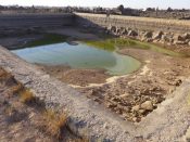
Figure 11. Reservoir with residue of rain-supplied water from the winter of 2014-5, 19-9-2015. 
Figure 12. A huge quantity of stone was thrown into the reservoir in the past 20 years. Foreman Ali Aqil serves as scale, 19-9-2015. 
Figure 13. The soil dried after the water was pumped out in late September. 21-10-2015. 
Figure 14. The last frog standing, 21-10-2015. - Getting started 19 Oct, 2015

Figure 15. Nearly a truckload of accumulated trash and garbage was collected before removal of stones and soil began. 19-10-2015. 
Figure 16. Removing stones from sediment basin 1, 19-10-2015. 
Figure 17. Sediment basin 2, stone removal, part 1. 19-10-2015 
Figure 18. Stone removal part 2. 19-10-2015 
Figure 19. Stone removal part 3. 19-10-2015 
Figure 20. Stone removal part 4; this completed the clearing of sediment basin 2, 19-10-2015. 
Figure 39. Contending with early rain. 7-11-2015. - Collecting the Garbage
- Clearing the Intake Sediment Trap.Part III of this report covers the progress of the work step by step because we consider the features of the actual work, the way everyone puts in extra effort and the way people work together is one of the very important components of this project. We use a communal decision making process in which everyone has a say for working out the details of the work strategy, like the manner of removing these stones from the sediment basins. A striking motif that ran through all the work portrayed in this section is characterized by the word “simplicity.” Over and over again, the collective preference was for executing tasks in the simplest ways possible. This included a constant preference for doing things by hand rather than with machines. While such choices meant greater physical effort, in the end the work was done more efficiently and more democratically, and with a minimum of damage to the reservoir structure. In the end, this built a sense of collective achievement; this team had done a major job in an outstanding manner together. That resulted in a very positive esprit de corps, and altogether, the manner and completion of this work also led to an improved community spirit, which rubbed off from the team to other members of the community. Thus the work process itself became an appropriate means for achieving the community engagement portion of the project’s goals.
- Clearing the Reservoir floor, 20 Oct – 13 Nov, 2015

Figure 21. Smaller stones were carried up the steps in a grand 15 minute ‘parade’ in which the 20 members of the Commodus Gate Preservation team participated. 21-10-2015. 
Figure 22. Stone and soil removal – experimental; it proved very difficult to flip the stones over the top edge. 22-10-2015. 
Figure 23 Stone up 1. 24-10-2015. 
Figure 24. Stone up 2. 24-10-2015. 
Figure 25. Stone up 3. 24-10-2015. 
Figure 26. Stone up 4. 24-10-2015. 
Figure 27. Stone up 5- over the edge! 24-10-2015. 
Figure 28. While stones were being removed, another part of the team began removing the soil using buckets and ropes. The strategy was to remove the thinner layers from the edges where bedrock was higher to isolate the deeper and thicker layer in the middle. This and the following 20 photographs show the soil ‘melt’ away until the final remnant is removed from the deeper center. 20-10-2015 
Figure 29. Soil removal – bucket by bucket, after the first rain, 26-10-2014 
Figure 30. Taking the high ground first – in a sea of wet sediment. 27-10-2015 
Figure 31. The rainfall was light, and the soil dried quickly. 29-10-2015 
Figure 32. NE corner 1. 1-11-2015 
Figure 33. NE corner 2. Full buckets ‘flew’ up rapidly, and mounds of soil accumulated. 1-11-2015. 
Figure 33. NE corner 2. Full buckets ‘flew’ up rapidly, and mounds of soil accumulated. 1-11-2015. 
Figure 35. Attacking the middle 2: four hours later, 12:02 pm, 2-11-2015. 
Figure 36. Each of two teams marked off squares for removal. 4-11-2015 
Figure 37. Arriving at the deep center. 5-11-2015. 
Figure 38. Stratified sediment, 50 cm deep. 5-11-2015. Figure 39. Contending with early rain. 7-11-2015. 
Figure 40. Pumping the puddles; the main challenge is to keep the water away from the soil. Shown here is a small pump provided by Mayor Hassan Fahed and his municipal staff. 7-11-2015. 
Figure 41. Another way was to dam up the puddles and move the water away sideways. 8-11-2015. 
Figure 42. Sunshine and evaporation proved the best drying agent! 8-11-2015 
Figure 43. After work, 8-11-2015. 
Figure 44. After overnight showers a rain-slicked floor made the work challenging. 9-11-2015. 
Figure 45. Final days: Racing the clock and racing the rain. 9-11-2015 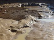
Figure 46. Left to be done in in the last 4 days, 10-13 November. 9-11-2015. 
Figure 47. Three days later, the last pocket of soil on the last day of scheduled team work. Photo by Muaffaq Hazza. 13-11-2015 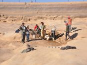
Figure 48. The last bit of sediment disappearing, 10 am, 13-11-2015. The team had chosen to work Friday instead of Saturday, to have their Grand Finale a day early! Photo by Muaffaq Hazza. 
Figure 49. Soil is gone! 14-11-2015. Photo by Muaffaq Hazza. 
Figure 50.Ali Aqil sweeping up, 13-11-2015. Photo by Muaffaq Hazza. 
Figure 51. Detol Chlorine and Dish Soap for the power wash solution. 14-11-2015. 
Figure 52. Mayor Hasan Fahed Rgaibeh starting power wash. 14-11-2015. 
Figure 53. Washing entire birkeh (reservoir). 14-11-2015. Photo by Muaffaq Hazza. 
Figure 54. … including the walls. For inscription see Fig. 5. 14-11-2015. Photo by Muaffaq Hazza. 
Figure 55. Clean Birkeh. 2:17 pm, 14-11-2014. Photo by Muaffaq Hazza. 
Figure 56. The following week some rains came. 17-11-2015. Photo by Muaffaq Hazza. 
Figure 57. Cleaned reservoir with clean water after the first rain, 19-11-2015. Photo by Muaffaq Hazza. - The Stone-Clearing PhaseWhen it proved difficult to bring large blocks over the top edge – because there was no leverage to flip them over – two long pipes, originally intended as components of a winch tripod, were ‘recruited’ to make an impromptu diagonal slide. After careful experimentation and testing for safety, this method of sliding the stones on the diagonal track proved successful, as shown in the following photo sequence.
- Sediment Soil Removal Phase
- Contending with Early Rains
- Completion of Sediment Removal
- Cleaning the empty reservoirThe final day without the team had the supervisors and municipality workers giove the entire reservoir a power washing, using a solution of Detol Chlorine and pink Dish Soap.Two tons of salt are ready to be added after the first major rainfall brings a substantial amount of water to the reservoir. This combination of soap-chlorine power washing and the salt additive is designed to eliminate residual pollutants and algae growing conditions.
- Ready for the Real Rains
- Removing the Excavated Sediment from Reservoir to the Village

Figure 58. Removing sediment mound from this and earlier cleanouts south side of reservoir. 7-11-2015. 
Figure 59. Onto dump small truck. 7-11-2015 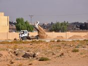
Figure 60. Sediment from reservoir supplies municipal street side landscaping soil. 8-11-2015 
Figure 61. The north wall of Houses 87 (right) & 88 (left) exposed after the removal of the long-term reservoir cleanout mound from its south side. 10-11-2015. Photo by Muaffaq Hazza. During the last week the Municipality provided earthmoving equipment and staff to move the soil taken out of the reservoir, especially the large mound on the south side, which accumulated from cleanouts beginning with the 1954-5 reconditioning. The soil was taken off site, and used to provide fertile soil for street-side plantings planned by the Municiplaity.
- Preparation and Assessment: Drying up the Sediment
- The Enablers: Participating People and Organizations

Figure 62. The crew. Ali Aqil, standing far right, was the group’s foreman whose work strategy enabled the completion of the reservoir reconditioning in four weeks. Photo by visitor, 7-11-2015. 
Figure 63. Contribution of the Municipality. Mayor Hassan Fahed (right) and Muaffaq Hazza. 7-11-2015 
Figure 64. Muaffaq Hazza, field director, and Ali Owaisi, DoA rep, discussing project strategy. 5-11-2015. - he crew: A Force in the Umm el-Jimal CommunityWe thank the intrepid and heroic team of 20 Umm el-Jimalis. See p. 12 for more accolades.
- Mayor Hasan Fahed al-Rgaibeh: A Force in The Umm el-Jimal MunicipalityWe thank Hasan Fahed, of the Umm el-Jimal Municipality, whose in-kind support and enthusiasm has turned the Water Project into a pioneering example of community engagement in archaeology.
- The Department of Antiquities: A Force in JordanWe thank the Department of Antiquities and Directo Genral Monther Jamhawi for its approval of the Water Project, and regional Director Abdul Qader al-Husan for the cooperative relationship in which equipment is shared. We are especially grateful for the generous and kind contributions of wise advice – and their assuring that departmental regulations were followed – by the DoA representatives who worked with us, Na’il Tuhamer, Mafraq, and Ali Owaisi, Jerash.
- NORHED Grant: Urban Transformation in the LevantWe thank Norway’s NORHED, Norwegian Programme for Capacity Development in Higher Education and Research for Development, for supporting the Umm el-Jimal Water Project as a component of the Birzeit University / University of Bergen “Urban Transformation” Project. We thank especially our team colleagues from these two universities for considering this work of the Umm el-Jimal Project as an integral component of the archaeology and community aspect of the grant.
- The Umm el-Jimal Project: A Force in ArchaeologyA special thanks goes to project team members Muaffaq Hazza, field director, and Ali Aqil, foreman, who’s brilliant planning and advice, collegiality and good humor have been essential for the success of this field work.
Conclusion: Water System Preservation, Community Engagement and “Urban Transformation”


- Work at the Rural Community Level
- Simplicity and Earthiness – the making of an experienced work forceThe work was completed through a combination of (1) careful planning on the premise of common-sense simplicity and the availability of affordable hand-tools, and (2) team building in which participants commit to work hard while celebrating the achievement of a common goal. The application of such a down-to-earth work strategy is ideal for community engagement training, because it creates a work force that can carry out its own projects quickly and well without reliance on costly outside “experts” and expensive machinery. The results are both excellent work and an experienced community work force that has the skill and structure to carry out similar archaeological site management projects on their own in the future.
- Becoming modern and the meaning of a living heritagePreservation and revival of the ancient runoff water collection and storage system puts the village participants in “contact” with their ancient counter parts in a real way. It is clear to them that the manner of their work replicates that of their ancient predecessors, and that the satisfaction that ancient hard work is the same satisfaction they receive. Moreover, they learn in the process that modern systems, such as deep well pumping, which were not available to the ancients, are not necessarily an improvement over that ancient system. As the deep well water table recedes and the water supply diminishes, their involvement in this project helps them to see that abandonment of the ancient system for the modern one was a tactical error. Instead, they now see that it is essential to balance their water supply by using these two sources in combination. Thus the ancient and modern technologies are joined in what may be called a “living heritage.”
- A Homecoming: Return to the Family Reservoir
As we worked together Mayor Hasan Fahed took us on a tour of other reservoirs, and pointed out that before 1970 the al- Rgaibeh clan had the water rights to Reservoir R19 (Figure 65 below) while they lived in the ancient houses of the northern sector of the Byzantine town, while other clans of the Masa’eid tribe had similar access rights to other reservoirs and houses. This means they had a system of rights of ownership and access that had become essential to the peaceful and prosperous civic structure of the mid-20th century Umm el-Jimal community, a system that became obsolete when they were excluded from the site. Memories of that civic structure survive among the traditional families of Umm el-Jimal each of whom still see themselves as having a “place” in the social geography of the ruins they inhabited. Revival of the reservoirs for modern reuse therefore, gives those who remember a sense of return and restoration. Such reconnection between modern residents and the antiquities in their midst should be seen as a significant component in the theme of “Urban Transformation,” which is here recognized not simply as an event driven by haphazard circumstances, but as a process that can be directed and influenced – in this case on the basis of archaeological research and preservation.
- A Return to Runoff Water Supply – reviving a technology
In the 1970s and 80s a significant portion of the community still relied on the Great Roman Reservoir’s water supply made available by the 1954-5 renovation. Herds of sheep and goats would gather daily at dusk to be watered from the concrete troughs, women would come with donkeys to draw household water into rubber saddle bags, sometimes camel herds came and also tanker trucks. The way the sight was fenced by the Department of Antiquities allowed for this access. Then when the deep wells were discovered in the 1990s and a municipal water supply developed, this reliance on the run-off collection system was abandoned. Now that the deep well water table is receding and the quality and quantity of pumped water diminishing, the technological knowledge of surface run-off collection, storage and redistribution needs to be recovered and an operating system redesigned for making this water supply sustainable.For example, our current efforts to clean and reactivate reservoirs cannot be seen as a one-time event. Rather, the accumulation of sediment carried by run-off water can fill in reservoirs like those at Umm el-Jimal and those behind dams at a relatively rapid rate. This has already been observed in the archaeological study of ancient water collection systems (for example, de Vries 1987: 404-405). There are instances in which newly constructed reservoirs silted up in a matter of only a few rainfall seasons. As is true of modern dam projects in Jordan (Ijam and Al-Mahamid 2012), the Umm el-Jimal system will have to be monitored for sediment accumulation in order to set a regular schedule of cleanouts as part of the routine maintenance and upkeep. Such monitoring may lead to the need of a newly designed filtering system that will prevent a significant percentage of sediment form entering the storage system.
Bibliography of Works Cited
- Butler, H. C. 1913 Umm idj-djimal, part 3 of Ancient Architecture in Syria, Section A, Southern Syria. Publications of the Princeton University Archaeological Expeditions to Syria in 1904-1905 and 1909. Leyden: E. J. Brill.
- Butler, H. C. 1914 Bosra, part 4 of Ancient Architecture in Syria, Section A, Southern Syria. Publications of the Princeton University Archaeological Expeditions to Syria in 1904-1905 and 1909. Leyden: E. J. Brill.
- de Vries, B. 1987 “The el-Lejjun Water System.” Ch 13 in S. Thomas Parker, ed. The Roman Frontier in Jordan: Interim Report on the Limes Arabicus Project, 1980-1985, Part i. Oxford: BAR International series 340(i)
- Ijam, A. Z. and M. H. Al-Mahamid 2012 “Predicting Sedimentation at the Mujib Dam Preserve in Jordan.” Jordan Journal of Civil Engineering, Vol 4, no. 4: 448-463.
- Kennedy, D., and D. Riley 1990 Rome’s Desert Frontier from the Air. London: B. T. Batsford Ltd.
- Kennedy, D., and R. Bewley 2004 Ancient Jordan from the Air. London: the Council of British Research in the Levant
- Namrouqa, H. 2013 “Roman-era reservoir restored,” Jordan Times, March 16, 2013; http://www.jordantimes.com/news/local/roman-era-reservoir-restored; accessed Nov. 18, 2015.