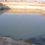
Figure 20. Reservoir 13 with water remaining to an average depth of one meter. In the foreground one can see the shelf of exposed bedrock floor and the algae bloom in the shallower water. 26 October 2016.
Figure 14. Leveled area looking south-southwest across Reservoir R19. 25 October 2016.
Fig. 6. Supply channel created by the Masa’eid to direct the overflow from R13 to Reservoir R7. 2 Nov. 2016.
Figure 4. Reservoir R7 cleaning completed. The Druze-constructed pillars supported the roof. 1 Nov. 2016
Figure 16. Reservoir R19 at end of season; final cleanup to be done in 2017. 2 November 2016.
Figure 5. The energetic crew that completed the R7 excavation. 20 Oct 2017.
Figure 12. Reservoir with rock and soil heaps; looking north. 11 Oct. 2016.
Figure 21. The dry south west corner of Reservoir 13 with its deposit of plastic bottles on top of algae ‘rooted’ in about 3 cm of new sediment. 26 October, 2016.
Figure 2. Reservoir R7 in courtyard of House 52 before work began. 10 Oct 2016.


